Mauritius Historical Map

 Maps of Mauritius
 All about Mauritius: Info & Tips
 Topographic Map
 Full Day Tours (Shopping, Sightseeing or Custom)
 Mauritius Must See & Do
 The History of Mauritius
 Location Map
 Roads Map
 Districts Map
 Hotels Map
 Attractions Map
 Satellite Map
 Hospitals & Clinics Map
 Mauritius Map: 1880 Edition
 Cities & Sights Guide
 Mauritius Sega Music, Dance & Instruments
 Beaches in Mauritius
 Mauritius Airport
 Tourism Industry
 Mauritius Geography & Dependencies
 Languages in Mauritius
 Shopping in Mauritius
 Mauritius Currency
 Land of the Dodos
 Mauritius Visa
 Best Time to Visit Mauritius
 Mauritius Video Gallery
 Best Places to Stay in Mauritius
 Mauritius' Must-See Spots
 Where is Mauritius?
 Mauritius Travel Advice
 Where to Stay in Mauritius?
 Street Food in Mauritius (with Recipes!)
 Most Popular Festivals Celebrated in Mauritius
 Medical Procedures & Wellness
 Ecotourism in Mauritius
 Mauritius Culture - Sports, Cuisine, Festivals & More
 Mauritius Travel & Safety Tips

 Scuba Diving in Mauritius
 Hiking and Trekking
 Mauritius Best Sea & Water Excursions
 Mauritius - A Top Fishing Destination
 Casinos Directory
 Best Places to Stay in Mauritius
 Mauritius' Must-See Spots
 Visit & Activities at Casela Nature Parks
 Trou aux Cerfs Volcano (Dormant)
 Rochester Falls - Popular Waterfall in Mauritius
 Discover Le Morne Brabant
 Mauritius Waterfalls
 Domaine de La Vieille Cheminée
 SSR Botanical Garden
 Castle in Mauritius - Château de Labourdonnais
 Eureka - La Maison Créole
 Black River Gorges National Park
 Highest Mountain in Mauritius
 Le Pouce Mountain
 Mauritius Tea Route - Le Domaine de Bois Chéri
 Domaine de Saint Aubin - Historical Sugar Estate
 Domaine des Aubineaux - French Colonial-Style House
 Mauritius Markets
 Discover our Waterfalls
 Churches in Mauritius
 Nature & Adventure Parks
 Water Activities in Mauritius
 10 Most Beautiful Mountains
 Breathtaking Viewpoints in Mauritius
 Hindu & Tamil Temples
 Rivers in Mauritius
 Street Food in Mauritius (with Recipes!)
 Top 10 Museums in Mauritius
 Ethereal Nature Lodges
 Islet Escapes Await
 Fun Activities for the Whole Family
 Day Cruises & Islet Visits
 15 Best Places to Go Shopping in Mauritius
 VIP & Luxury Packages
 Self-Catering Apartments
 Animal Encounters in Mauritius
 Must-Try Water Sports
 Play Golf in Paradise
 Sightseeing Tours & Packages
 Scuba Diving Destination

 Mauritius Excursions (120+ Options)
 Scuba Diving in Mauritius
 Catamaran Cruises, Yachts, Speed Boats & More
 Sea & Water Activities
 Hiking and Trekking
 PADI & CMAS Diving Courses
 Yacht Cruises
 Full Day Tours (Shopping, Sightseeing or Custom)
 Ile Aux Cerfs Mauritius (Island Tours)
 Mauritius Top Land Excursions
 Mauritius Best Sea & Water Excursions
 Underwater Experiences in Mauritius
 Flight Excursions in Mauritius
 Golf Resorts in Mauritius
 Cities & Sights Guide
 Overnight Catamaran Cruises
 La Vanille Nature Park (Giant Tortoises & Crocodile Reserve)
 Mauritius - A Dream Destination Spot
 Holidaying with Your Kids?
 Mauritius' Ultimate Marine Adventure

 Mauritius Excursions (120+ Options)
 Scuba Diving in Mauritius
 Catamaran Cruises, Yachts, Speed Boats & More
 PADI & CMAS Diving Courses
 Yacht Cruises
 Full Day Tours (Shopping, Sightseeing or Custom)
 Ile Aux Cerfs Mauritius (Island Tours)
 Mauritius Top Land Excursions
 Underwater Experiences in Mauritius
 Flight Excursions in Mauritius
 Golf Resorts in Mauritius
 Overnight Catamaran Cruises
 Discover the Underwater World
 Flight Trips & Aerial Activities
 Catamaran Cruises
 Must-Try Unique Activities in Mauritius
 Romantic Things To Do in Mauritius
 Hike the Best Trails: From Waterfalls to Mountain Peaks
 Indoor Activities for a Rainy Day
 Top 10 Adrenaline-Filled Adventures in Mauritius
 Evening Activities in Mauritius
 Mauritius' Must-Do Activities
 Activities in the North of Mauritius
 Mauritius Underwater Waterfall: An Illusion?
 Wildlife Parks in Mauritius
 Holidaying with Your Kids?

 Visit & Activities at Casela Nature Parks
 Trou aux Cerfs Volcano (Dormant)
 Rochester Falls - Popular Waterfall in Mauritius
 Discover Le Morne Brabant
 Mauritius Waterfalls
 La Vanille Nature Park (Giant Tortoises & Crocodile Reserve)
 Black River Gorges National Park
 Highest Mountain in Mauritius
 Le Pouce Mountain
 Nature & Adventure Parks
 10 Most Beautiful Mountains
 Rivers in Mauritius
 Mauritius Underwater Waterfall: An Illusion?
 Wildlife Parks in Mauritius
 Mauritius Lava Tube Caves

 Blue Penny Museum
 Ganga Talao (Grand Bassin)
 Domaine de La Vieille Cheminée
 SSR Botanical Garden
 Historic Site - Aapravasi Ghat
 Castle in Mauritius - Château de Labourdonnais
 Eureka - La Maison Créole
 The Citadel Fort (Fort Adelaide)
 Mauritius Postal Museum
 The Martello Tower Museum
 Indian Immigration Museum
 Mahébourg Naval and History Museum
 Mauritius Tea Route - Le Domaine de Bois Chéri
 Domaine de Saint Aubin - Historical Sugar Estate
 Domaine des Aubineaux - French Colonial-Style House
 Hindu & Tamil Temples
 Historical & Heritage Sites
 Mauritius Historical Sites
 Mauritius Top Arts & Cultural Events

 Mauritius National Holidays & Festivals
 Divali - The Festival of Lights
 Maha Shivaratri Festival
 Thaipoosam Cavadee Festival
 Traditions, Cuisines and Festivities in Mauritius
 Events and Festivals in Mauritius
 Père Laval Mauritius
 Ugadi Festival
 Eid-Al-Fitr in Mauritius
 Most Popular Festivals Celebrated in Mauritius
 Mauritius Culture - Sports, Cuisine, Festivals & More

 Flic en Flac
 Grand Baie - Mauritius
 Port Louis - The Capital of Mauritius
 The Village of Chamarel - Mauritius
 Quatre Bornes (Four Boundaries)
 Grand Gaube
 Albion
 Belle Mare
 Ebene Cybercity
 Cap Malheureux
 Bel Ombre
 Mahebourg
 Trou d’Eau Douce
 Trou aux Biches
 Curepipe
 Tamarin
 Péreybère
 Majestic Natural Wonders That Will Amaze You
 Blue Bay
 Goodlands
 Uncover the Best Coastal Spots in the North of Mauritius
 Balaclava
 Dive into Mauritius’ Historic Hub and Scenic Wonders
 Mont Choisy
 Le Morne
 Mauritius Markets
See More
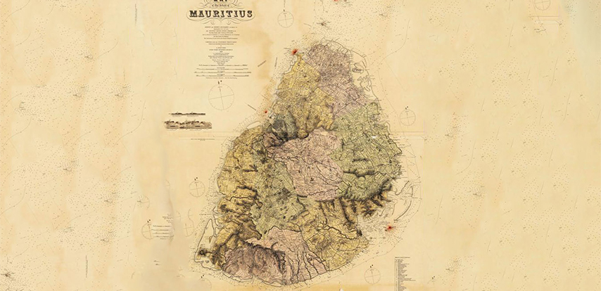
Mauritius Historical Map from year 1880
For those who are more fans of history, the map below offers a very unique overview of Mauritius from over 100 years ago, during the 19th century when the British govern Mauritius. The map was published at the year 1880, while the majority of the information and date obtained during the period of 1850 – 1875.
It is quite remarkable to see how the map is so accurate while referring to the topography of Mauritius.
The map includes information on all mountains, rivers, villages, islets and many more.
It also offers a great presentation of the various provinces of Mauritius and the border of each province during that period in time.
Unique to this map is details on all the estate plans, title deeds, and land plots and these were allocated during that period.
Click on the map image to see a larger image of the Mauritius Historical map.
This Mauritius Historical Map is a true piece of art a result of much hard work and a lot of skill in map making.
Mauritius Historical Map
Mauritius during the early days: Mauritius Island first appears on the map during the 16th century after being discovered by the Arabs. Few years after Mauritius appeared first in maps produced in Europe as one of the group of islands located south east of Madagascar. On this map, Mauritius was known as Dina Arobi which was the name first given to Mauritius by the Arabs.


